
Guidebook for Your Stay
Sightseeing
The grounds and structures are beautiful and well maintained. The inside may be closed due to covid, check online first. The grounds are open sun up to sun down year round. Parking is available 9am-4:30pm daily
54 moradores locais recomendam
Sítio histórico nacional de Grey Towers
151 Grey Towers DrThe grounds and structures are beautiful and well maintained. The inside may be closed due to covid, check online first. The grounds are open sun up to sun down year round. Parking is available 9am-4:30pm daily
Address: 105 Fisher Ln, Milford, PA 18337
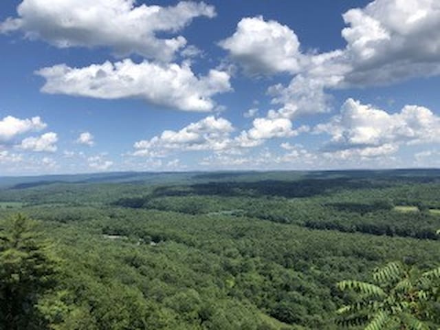
Hackers Falls and Cliff Trail Loop is a 3.6 mile heavily trafficked loop trail located near Milford, Pennsylvania that features a lake and is rated as moderate. The trail is primarily used for hiking and is best used from April until October.
When arriving at the parking lot for the Pond Loop Trail, there will be two paths onto the trail. Take the one on the left. It will lead you down to the side of the pond that has a small dock, a bench, a nice little picnic area.
21 moradores locais recomendam
Hackers Falls
105 Fisher LnAddress: 105 Fisher Ln, Milford, PA 18337
Hackers Falls and Cliff Trail Loop is a 3.6 mile heavily trafficked loop trail located near Milford, Pennsylvania that features a lake and is rated as moderate. The trail is primarily used for hiking and is best used from April until October.
When arriving at the parking lot for the Pond Loop Trail, there will be two paths onto the trail. Take the one on the left. It will lead you down to the side of the pond that has a small dock, a bench, a nice little picnic area.
917 Raymondskill Rd, Milford, PA 18337
Length: 0.3 mile, one-way
Difficulty: Easy-moderate
Restrictions: Swimming and wading are not permitted within 50 feet upstream of waterfalls or in the waterfalls themselves
The three-tiered Raymondskill Falls is the tallest waterfall in Pennsylvania. If you add the drops from each tier together, the waterfall is only a few feet shorter than Niagara Falls. While the trail is short, it is fairly steep and uneven. The upper viewing area provides a view of the upper pool and the top of one of the drops. The lower viewing area provides a great photo opportunity of the falls. A spur off the main trails provides a quarter-mile, one-way walk to Raymondskill Creek (this trail does not lead to the bottom of the falls).
Other Information: restroom located at trailhead
88 moradores locais recomendam
Cachoeira de Raymondskill
917 Raymondskill Rd, Milford, PA 18337
Length: 0.3 mile, one-way
Difficulty: Easy-moderate
Restrictions: Swimming and wading are not permitted within 50 feet upstream of waterfalls or in the waterfalls themselves
The three-tiered Raymondskill Falls is the tallest waterfall in Pennsylvania. If you add the drops from each tier together, the waterfall is only a few feet shorter than Niagara Falls. While the trail is short, it is fairly steep and uneven. The upper viewing area provides a view of the upper pool and the top of one of the drops. The lower viewing area provides a great photo opportunity of the falls. A spur off the main trails provides a quarter-mile, one-way walk to Raymondskill Creek (this trail does not lead to the bottom of the falls).
Other Information: restroom located at trailhead
608 Broad St, Milford, PA 18337
Exhibits of artwork & artifacts preserving Pike County history in a neoclassical mansion from 1904.
15 moradores locais recomendam
The Columns Museum of the Pike County Historical Society
608 Broad St 608 Broad St, Milford, PA 18337
Exhibits of artwork & artifacts preserving Pike County history in a neoclassical mansion from 1904.
The Niagara of Pennsylvania.
Bushkill Falls
Bushkill Falls Road
Bushkill, PA 18324
https://www.visitbushkillfalls.com/discover/park-hours-general-information/
Operating Season
Operating hours at Bushkill Falls vary depending on season, day of week, and weather. Generally, we open at 9:00 am and close at 4:00 pm, 5:00 pm, 6:00 pm, or 7:00 pm. Ticket sales, shops, food service, and events all stop 1 hour prior to park closing. We are closed December through March.
The Boat House is open on weekends only in the Spring and Fall. It is open 7 days a week, weather permitting, from July 4th through Labor Day. Hours of operation are 11:30 am until 5:00 pm.
To find out if we are open or closed, be sure to check our homepage where we will have this information posted, as well as listed on the Operating Schedule below.
General Information
Pets Pets are permitted in the park, but must remain on a leash and not left unattended anywhere on the grounds.
Restrooms The restrooms are located in the corner of the parking lot between the Outfitters and The Story of Bushkill Falls.
Cell Phone Reception There is sporadic cell service throughout the property. Service is sometimes available near the front gate.
First-Aid
First-aid is available at the office located at the rear of the Main Stand.
706 moradores locais recomendam
Cachoeiras de Bushkill
The Niagara of Pennsylvania.
Bushkill Falls
Bushkill Falls Road
Bushkill, PA 18324
https://www.visitbushkillfalls.com/discover/park-hours-general-information/
Operating Season
Operating hours at Bushkill Falls vary depending on season, day of week, and weather. Generally, we open at 9:00 am and close at 4:00 pm, 5:00 pm, 6:00 pm, or 7:00 pm. Ticket sales, shops, food service, and events all stop 1 hour prior to park closing. We are closed December through March.
The Boat House is open on weekends only in the Spring and Fall. It is open 7 days a week, weather permitting, from July 4th through Labor Day. Hours of operation are 11:30 am until 5:00 pm.
To find out if we are open or closed, be sure to check our homepage where we will have this information posted, as well as listed on the Operating Schedule below.
General Information
Pets Pets are permitted in the park, but must remain on a leash and not left unattended anywhere on the grounds.
Restrooms The restrooms are located in the corner of the parking lot between the Outfitters and The Story of Bushkill Falls.
Cell Phone Reception There is sporadic cell service throughout the property. Service is sometimes available near the front gate.
First-Aid
First-aid is available at the office located at the rear of the Main Stand.
https://www.alltrails.com/trail/us/pennsylvania/milford-knob-trail
Milford Knob Trail is a 3.5 mile moderately trafficked loop trail located near Milford, Pennsylvania that features beautiful wild flowers and is rated as moderate. The trail offers a number of activity options and is accessible year-round. Dogs are also able to use this trail but must be kept on leash.
Directions:
4 min (0.8 mile)
via 7th St and W Harford St
Fastest route
316 W High St
Milford, PA 18337
Head northwest on W High St toward Foster Hill Rd
43 ft
Turn left onto 7th St
0.2 mi
Turn left onto W Harford St
0.3 mi
Turn right onto Broad St
433 ft
Turn right onto Sawkill Ave
305 ft
Turn left onto Wycoff Ln
0.1 mi
Wycoff Ln turns right and becomes Quarter Horse Ln
7 ft
The Milford Knob
9 moradores locais recomendam
Milford Knob Trailhead
https://www.alltrails.com/trail/us/pennsylvania/milford-knob-trail
Milford Knob Trail is a 3.5 mile moderately trafficked loop trail located near Milford, Pennsylvania that features beautiful wild flowers and is rated as moderate. The trail offers a number of activity options and is accessible year-round. Dogs are also able to use this trail but must be kept on leash.
Directions:
4 min (0.8 mile)
via 7th St and W Harford St
Fastest route
316 W High St
Milford, PA 18337
Head northwest on W High St toward Foster Hill Rd
43 ft
Turn left onto 7th St
0.2 mi
Turn left onto W Harford St
0.3 mi
Turn right onto Broad St
433 ft
Turn right onto Sawkill Ave
305 ft
Turn left onto Wycoff Ln
0.1 mi
Wycoff Ln turns right and becomes Quarter Horse Ln
7 ft
The Milford Knob
High Point Monument and State Park
https://www.state.nj.us/dep/parksandforests/parks/highpoint.html
Hiking, bicycling, Monument, and beach area.
The view from High Point Monument, at 1,803 feet above sea level, is a spectacular panorama of rich farmland and forest, soft hills and lush valleys in three states. The blue line of the Delaware River divides the verdant ridges of New Jersey from those of Pennsylvania.
Fees: Entrance fees are charged per vehicle from Memorial Day weekend to Labor Day.
NJ Resident
Non-Resident
$ 5.00
$10.00
weekdays
$10.00
$20.00
weekends/holidays
N/A
N/A
walk-in/bicycle
$ 5.00
$ 7.00
motorcycle
73 moradores locais recomendam
High Point State Park Office
1480 NJ-23High Point Monument and State Park
https://www.state.nj.us/dep/parksandforests/parks/highpoint.html
Hiking, bicycling, Monument, and beach area.
The view from High Point Monument, at 1,803 feet above sea level, is a spectacular panorama of rich farmland and forest, soft hills and lush valleys in three states. The blue line of the Delaware River divides the verdant ridges of New Jersey from those of Pennsylvania.
Fees: Entrance fees are charged per vehicle from Memorial Day weekend to Labor Day.
NJ Resident
Non-Resident
$ 5.00
$10.00
weekdays
$10.00
$20.00
weekends/holidays
N/A
N/A
walk-in/bicycle
$ 5.00
$ 7.00
motorcycle
224 Dingmans Falls Road
Dingmans Ferry, PA 18328
Dingmans Falls is the second highest waterfall in the state, with a plunge of 130 feet.
Updated: Limited services available. Visit responsibly - Most park trails and boat launches are open, but some restrooms are closed and services are limited. Law enforcement is on duty. All park regulations apply. Visit this park webpage for more details.
Starting at the on-site visitors center, the flat boardwalk trail to Dingmans Falls meanders through a beautiful hemlock ravine. Almost immediately after starting the trail, Silverthread Falls can be seen on the right. The cascade gracefully drops 80 feet through a narrow chute. Past Silverthread Falls, the trail winds through rhododendron shrubs and by tall hemlock trees, a short distance to the waterfall. The boardwalk ends at the base of Dingmans Falls, the second highest waterfall in Pennsylvania. View the falls from the platform or trek the final tenth of a mile via staircase for a birds-eye view from the upper falls.
75 moradores locais recomendam
Dingmans Falls
Dingmans Falls Road224 Dingmans Falls Road
Dingmans Ferry, PA 18328
Dingmans Falls is the second highest waterfall in the state, with a plunge of 130 feet.
Updated: Limited services available. Visit responsibly - Most park trails and boat launches are open, but some restrooms are closed and services are limited. Law enforcement is on duty. All park regulations apply. Visit this park webpage for more details.
Starting at the on-site visitors center, the flat boardwalk trail to Dingmans Falls meanders through a beautiful hemlock ravine. Almost immediately after starting the trail, Silverthread Falls can be seen on the right. The cascade gracefully drops 80 feet through a narrow chute. Past Silverthread Falls, the trail winds through rhododendron shrubs and by tall hemlock trees, a short distance to the waterfall. The boardwalk ends at the base of Dingmans Falls, the second highest waterfall in Pennsylvania. View the falls from the platform or trek the final tenth of a mile via staircase for a birds-eye view from the upper falls.
The visitor center is off of US 209, just south of the 209/739 junction.
Silverthread Falls is a thin tall falls in Delaware Water Gap National Park. The trail head for this falls starts at the Dingmans Falls Visitor center. This is by far the easiest waterfall to visit in the area. From the parking lot it is a walk of less than 200 feet on level accessible boardwalk to the base of the falls.
The waterfall is aptly named. The stream has found a natural seam in the rock resulting in a thin thread of a falls. The rock has been cut nearly perfectly straight in some cases, almost as if blocks had been quarried out.
Silverthread Falls
The visitor center is off of US 209, just south of the 209/739 junction.
Silverthread Falls is a thin tall falls in Delaware Water Gap National Park. The trail head for this falls starts at the Dingmans Falls Visitor center. This is by far the easiest waterfall to visit in the area. From the parking lot it is a walk of less than 200 feet on level accessible boardwalk to the base of the falls.
The waterfall is aptly named. The stream has found a natural seam in the rock resulting in a thin thread of a falls. The rock has been cut nearly perfectly straight in some cases, almost as if blocks had been quarried out.
546 NY-97, Sparrow Bush, NY 12780
Excellent Motorcycle Route, fun for cars too! Great views
40 moradores locais recomendam
Hawks Nest
546 NY-97, Sparrow Bush, NY 12780
Excellent Motorcycle Route, fun for cars too! Great views
Neighborhoods
Full of history, a variety of small shops and local eateries. We are 0.4 miles (a short walk) to downtown Milford
120 moradores locais recomendam
Milford
Full of history, a variety of small shops and local eateries. We are 0.4 miles (a short walk) to downtown Milford
Food scene
Local coffee stop, short walk (0.2 miles)
located in the Lumberyard Shoppes
115 7th St, Milford, PA 18337
Sun - Thursday 5am-6pm
Fri & Sat 5am-7pm
7 moradores locais recomendam
Milford's Daily Grind
115 7th StLocal coffee stop, short walk (0.2 miles)
located in the Lumberyard Shoppes
115 7th St, Milford, PA 18337
Sun - Thursday 5am-6pm
Fri & Sat 5am-7pm
Village Diner
268 209Old school Americana Diner. Our personal favorite spot to grab food in the area.
Sunday 10AM–8PM
Monday 4–9:30PM
Tuesday 4–9:30PM
Wednesday 4–9:30PM
Thursday 4-9:30
Friday 4-10:30
7 moradores locais recomendam
Jive Bar and Lounge
319 Broad St
Sunday 10AM–8PM
Monday 4–9:30PM
Tuesday 4–9:30PM
Wednesday 4–9:30PM
Thursday 4-9:30
Friday 4-10:30
Love The Outdoor Seating on Main Street.
Sunday 11am-8pm
Mon-Sat 11:30am-9pm
49 moradores locais recomendam
Dimmick Inn & Steakhouse
101 E Harford StLove The Outdoor Seating on Main Street.
Sunday 11am-8pm
Mon-Sat 11:30am-9pm
Bar Louis
401 Broad StSun 12p-3p & 5p-8p
Mon-Wed Closed
Thurs - Saturday 5p-8p
Milford Diner
301 Broad StOpen 6am-10pm 7 days a week
Local Beaches
150 Milford Beach Road, Milford, PA 18337
Milford Beach is located at the north end of the park just south of Milford, PA. This area offers a grassy beach complete with picnic areas, a pavilion, restrooms, a boat launch, a canoe launch, and access to the Joseph M. McDade Recreational Trail.
ACCESSIBILITY NOTES
Milford Beach is closed to pets from Memorial Day to Labor Day, except when launching and retrieving motorized and/or non-motorized vessels at designated launch sites or when accessing the McDade Trailhead for the purpose of utilizing the trail.
RECREATIONAL OPPORTUNITIES
The park provides three lifeguarded beaches where visitors can safely enjoy a swim in the Delaware River. Lifeguards are on duty weekends from mid-June through August. Picnic and restroom facilities are also available at the beaches. Grills are not provided;personal grills are permitted. Alcohol and pets are not permitted.
Safe Swimming Guidelines
Swimming in areas of the river outside the life guarded beaches is permitted, but not recommended. Strong currents, sharp drop-offs, and constantly changing river conditions make many areas unsafe for swimming.
Wearing a properly fitting life jacket is strongly recommended when swimming.
Never swim alone.
Never try to swim across the river. Currents are deceiving;many people have drowned attempting to swim from one side of the river to the other.
Apply sunscreen often to avoid sunburns.
*Swimming Restrictions**
Swimming is not permitted within 50 feet of a boat launch, a canoe launch, or the top of any waterfall. Additionally, swimming is not permitted at the following areas:
Kittatinny Point, NJ
Van Campens Glen, NJ
Dingmans Falls, PA
George W. Childs Recreation Site, PA
SEASONS ACCESSIBLE
Milford Beach is accessible year-round, however lifeguards are only available seasonally.
Expanded Amenity Fee Schedule
No fee is charged for those who are dropping off or picking up people from the river access ramps and those walking through Smithfield Beach on McDade Recreational Trail. Expanded Amenity Fees are not covered by America the Beautiful Annual Pass. However, holders of the America the Beautiful Senior and Access Passes, and National Park Service Golden Age and Golden Access Passes are eligible for a 50% discount on the Expanded Amenity Fees.
Private vehicle (up to 7 persons): $7.00 per vehicle on a weekday
Private vehicle (up to 7 persons): $10.00 per vehicle on a Saturday, Sunday, or holiday
Vehicles with 8 or more adults (age 16 or older): $1.00 per person
Pedestrian (age 16 or older): $1.00 per person
Delaware Water Gap National Recreation Area Season Passes
Season passes can be purchased at park headquarters, Dingmans Falls Visitor Center, Kittatinny Point Visitor Center, staffed collection stations, or through the mail. Holders of the America the Beautiful Senior and Access Passes and National Park Service Golden Age and Golden Access Passes are eligible for a 50% discount on season passes.
Fees are charged at the beaches April through October.
For More Information
Call (570) 426-2434 for more information about fees and passes.
PRICING
Season Pass: $45; A second Season Pass registered to the same name and address: $25; A third Season Pass registered to the same name and address: $12.50; Walk-In Season Pass: $10.00
22 moradores locais recomendam
Milford Beach
150 Milford Beach Rd150 Milford Beach Road, Milford, PA 18337
Milford Beach is located at the north end of the park just south of Milford, PA. This area offers a grassy beach complete with picnic areas, a pavilion, restrooms, a boat launch, a canoe launch, and access to the Joseph M. McDade Recreational Trail.
ACCESSIBILITY NOTES
Milford Beach is closed to pets from Memorial Day to Labor Day, except when launching and retrieving motorized and/or non-motorized vessels at designated launch sites or when accessing the McDade Trailhead for the purpose of utilizing the trail.
RECREATIONAL OPPORTUNITIES
The park provides three lifeguarded beaches where visitors can safely enjoy a swim in the Delaware River. Lifeguards are on duty weekends from mid-June through August. Picnic and restroom facilities are also available at the beaches. Grills are not provided;personal grills are permitted. Alcohol and pets are not permitted.
Safe Swimming Guidelines
Swimming in areas of the river outside the life guarded beaches is permitted, but not recommended. Strong currents, sharp drop-offs, and constantly changing river conditions make many areas unsafe for swimming.
Wearing a properly fitting life jacket is strongly recommended when swimming.
Never swim alone.
Never try to swim across the river. Currents are deceiving;many people have drowned attempting to swim from one side of the river to the other.
Apply sunscreen often to avoid sunburns.
*Swimming Restrictions**
Swimming is not permitted within 50 feet of a boat launch, a canoe launch, or the top of any waterfall. Additionally, swimming is not permitted at the following areas:
Kittatinny Point, NJ
Van Campens Glen, NJ
Dingmans Falls, PA
George W. Childs Recreation Site, PA
SEASONS ACCESSIBLE
Milford Beach is accessible year-round, however lifeguards are only available seasonally.
Expanded Amenity Fee Schedule
No fee is charged for those who are dropping off or picking up people from the river access ramps and those walking through Smithfield Beach on McDade Recreational Trail. Expanded Amenity Fees are not covered by America the Beautiful Annual Pass. However, holders of the America the Beautiful Senior and Access Passes, and National Park Service Golden Age and Golden Access Passes are eligible for a 50% discount on the Expanded Amenity Fees.
Private vehicle (up to 7 persons): $7.00 per vehicle on a weekday
Private vehicle (up to 7 persons): $10.00 per vehicle on a Saturday, Sunday, or holiday
Vehicles with 8 or more adults (age 16 or older): $1.00 per person
Pedestrian (age 16 or older): $1.00 per person
Delaware Water Gap National Recreation Area Season Passes
Season passes can be purchased at park headquarters, Dingmans Falls Visitor Center, Kittatinny Point Visitor Center, staffed collection stations, or through the mail. Holders of the America the Beautiful Senior and Access Passes and National Park Service Golden Age and Golden Access Passes are eligible for a 50% discount on season passes.
Fees are charged at the beaches April through October.
For More Information
Call (570) 426-2434 for more information about fees and passes.
PRICING
Season Pass: $45; A second Season Pass registered to the same name and address: $25; A third Season Pass registered to the same name and address: $12.50; Walk-In Season Pass: $10.00
Beach area in the park. Entrance Fees apply
73 moradores locais recomendam
High Point State Park Office
1480 NJ-23Beach area in the park. Entrance Fees apply
Activities
Zip-lines, paintball, rafting down the Delaware.
https://kittatinny.com/adventures/
39 moradores locais recomendam
Kittatinny Canoes
378 U.S. 6Zip-lines, paintball, rafting down the Delaware.
https://kittatinny.com/adventures/
Pittman Orchard McDade Trail Access
Federal Rd, Milford, PA 18337
https://www.traillink.com/trail/joseph-m-mcdade-recreational-trail/
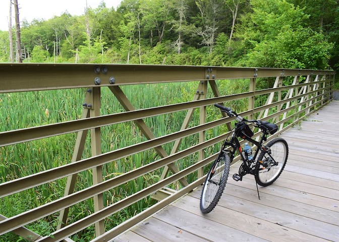
The Joseph M. McDade Recreational Trail runs nearly the length of the Delaware Water Gap National Recreation Area on the Pennsylvania side of the Delaware River across from New Jersey. The protected area preserves the flora and fauna, as well as historical and archaeological sites, in a steep gorge that the river carved through a ridge in the Appalachian Mountains. Several waterfalls crash off the cliffs.
The federal government acquired the land through which the trail runs in the 1950s to the 1970s for a flood-control dam. The government officially abandoned the dam project in the 1990s, though it was voted down in 1975 due to opposition from scientists and displaced residents. The National Park Service then acquired the 40-mile-long corridor for the recreation area. It named the trail along the river for the late Joseph M. McDade, a congressman who represented the district.
The crushed-stone path is mostly flat along its 31.3-mile course along the river, except for a nearly mile-long section that climbs from the river to the visitor center on a ridge overlooking the southern section. Trailheads are less than 5 miles apart and are connected by a free bus shuttle that runs on weekends through the summer. A 2.5-mile section below the cliff face between the Conashaugh and Pittman Orchard trailheads (miles 26 to 28.5) is closed December 15–July 15 every year to avoid disturbing nesting eagles.
Starting at the Hialeah trailhead in East Stroudsburg, the trail runs along a fairly flat segment through the woods along the river for about 6 miles to the Owens trailhead, where it climbs a ridge on switchbacks for 0.7 mile to the park’s visitor center. Observation platforms here allow visitors to see the river below and wildlife.
The next 3.5 miles cross rolling terrain into the Bushkill area, once a busy resort and farming community. Archaeological studies here also reveal American Indians once thrived in this area. The trail runs between US 209 and the Delaware River over the next several miles, arriving at the former site of the Egypt Mills.
The trail variously passes through cropland and forests to a good view of the river at Eshback Access, a boat launching site. The woods north of here teem with wildlife, and you may see bears and deer along with squirrels, chipmunks, and raccoons. The longest stretch between trailheads—5.3 miles—occurs between Jerry Lees trailhead and Schneider Farm trailhead at mile 21.4.
In another 1.1 miles you’ll reach the Dingmans Campground, which has 133 campsites. (No backcountry camping is permitted west of the Delaware River, and river campsites are reserved for boaters.) The trail and US 209 follow a narrow band between the river and cliffs for much of the remaining 9 miles. You’ll come to the popular Raymondskill Falls about 6 miles past the campground.
Parking and Trail Access
To reach the Hialeah trailhead from I-80, take Exit 310 for SR 611/Delaware Water Gap. If coming from I-80 W, continue on the ramp 0.5 mile and exit to the right to merge onto River Road. If coming from I-80 E, turn left onto River Road (part of this road is closed in winter). Go 4.0 miles, and turn right onto the access road for the Delaware Water Gap National Recreation Area. Go about 490 feet, and turn left onto another access road, and then go 0.1 mile to the trailhead.
To reach the northern endpoint at Milford Beach trailhead from I-84, take Exit 46 for US 6 toward Milford, and head southeast on US 6 E. Go 2.2 miles, and continue straight onto E. Hartford St. Go 0.5 mile, and turn left onto Milford Beach Road/SR 2013. Go 0.5 mile, and look for parking in the lot.
McDade Trail
McDade TrailPittman Orchard McDade Trail Access
Federal Rd, Milford, PA 18337
https://www.traillink.com/trail/joseph-m-mcdade-recreational-trail/
The Joseph M. McDade Recreational Trail runs nearly the length of the Delaware Water Gap National Recreation Area on the Pennsylvania side of the Delaware River across from New Jersey. The protected area preserves the flora and fauna, as well as historical and archaeological sites, in a steep gorge that the river carved through a ridge in the Appalachian Mountains. Several waterfalls crash off the cliffs.
The federal government acquired the land through which the trail runs in the 1950s to the 1970s for a flood-control dam. The government officially abandoned the dam project in the 1990s, though it was voted down in 1975 due to opposition from scientists and displaced residents. The National Park Service then acquired the 40-mile-long corridor for the recreation area. It named the trail along the river for the late Joseph M. McDade, a congressman who represented the district.
The crushed-stone path is mostly flat along its 31.3-mile course along the river, except for a nearly mile-long section that climbs from the river to the visitor center on a ridge overlooking the southern section. Trailheads are less than 5 miles apart and are connected by a free bus shuttle that runs on weekends through the summer. A 2.5-mile section below the cliff face between the Conashaugh and Pittman Orchard trailheads (miles 26 to 28.5) is closed December 15–July 15 every year to avoid disturbing nesting eagles.
Starting at the Hialeah trailhead in East Stroudsburg, the trail runs along a fairly flat segment through the woods along the river for about 6 miles to the Owens trailhead, where it climbs a ridge on switchbacks for 0.7 mile to the park’s visitor center. Observation platforms here allow visitors to see the river below and wildlife.
The next 3.5 miles cross rolling terrain into the Bushkill area, once a busy resort and farming community. Archaeological studies here also reveal American Indians once thrived in this area. The trail runs between US 209 and the Delaware River over the next several miles, arriving at the former site of the Egypt Mills.
The trail variously passes through cropland and forests to a good view of the river at Eshback Access, a boat launching site. The woods north of here teem with wildlife, and you may see bears and deer along with squirrels, chipmunks, and raccoons. The longest stretch between trailheads—5.3 miles—occurs between Jerry Lees trailhead and Schneider Farm trailhead at mile 21.4.
In another 1.1 miles you’ll reach the Dingmans Campground, which has 133 campsites. (No backcountry camping is permitted west of the Delaware River, and river campsites are reserved for boaters.) The trail and US 209 follow a narrow band between the river and cliffs for much of the remaining 9 miles. You’ll come to the popular Raymondskill Falls about 6 miles past the campground.
Parking and Trail Access
To reach the Hialeah trailhead from I-80, take Exit 310 for SR 611/Delaware Water Gap. If coming from I-80 W, continue on the ramp 0.5 mile and exit to the right to merge onto River Road. If coming from I-80 E, turn left onto River Road (part of this road is closed in winter). Go 4.0 miles, and turn right onto the access road for the Delaware Water Gap National Recreation Area. Go about 490 feet, and turn left onto another access road, and then go 0.1 mile to the trailhead.
To reach the northern endpoint at Milford Beach trailhead from I-84, take Exit 46 for US 6 toward Milford, and head southeast on US 6 E. Go 2.2 miles, and continue straight onto E. Hartford St. Go 0.5 mile, and turn left onto Milford Beach Road/SR 2013. Go 0.5 mile, and look for parking in the lot.